Cambodia
Temples of Angkor
Temples of Angkor
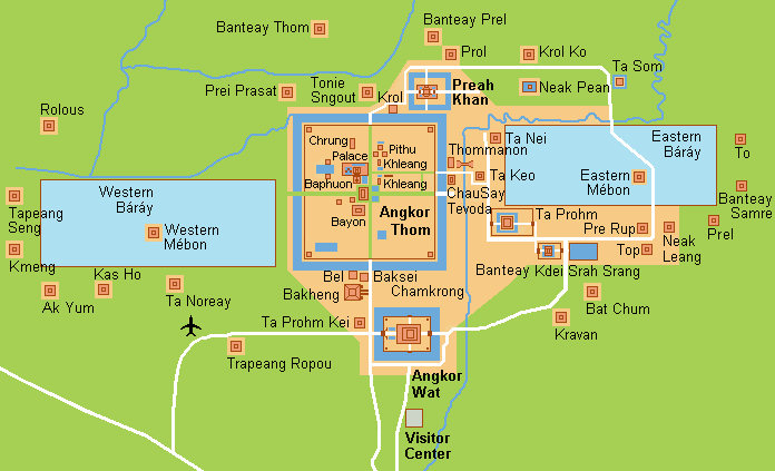
The temples of Angkor are the heart en soul of the Kingdom of Cambodia, a source of inspiration and national pride to all Khmers
as they struggle to rebuild their lives after the years of terror and trauma.
The temples of Angkor were built between the 9th and 14th centuries AD, when Khmer civilisation was at the height of its extraordinary
creativity. From Angkor the kings of the mighty Khmer empire ruled over a vast territory that extended from the tip of what is now
southern Vietnam, north to Yunnan in China and from Vietnam west to the Bay of Bengal.
Angkor's 100 or so temples constitute the sacred skeleton of a spectacular administrative and religious centre. Its houses, public
buildings and palaces were constructed of wood - now long decayed - because the right to dwell in structures of brick or stone was
reserved for the gods.
With the exception of Angkor Wat, which was restored for the use as a Buddhist shrine in the 16th century by the Khmer royalty, the
monuments of Angkorwere left to the jungle for many centuries.
It was the publication of "Voyage á Siam et dans le Cambodge" by Henri Mouhot in 1868 that first brought Angkor to
the public eye. Although the explorer himself made nu such claim, by the 1970s he was being posthumously celebrated as the discovere of
the lost temple city of Cambodia. The fact is, a French missionary known as Charles-Emile Bouillevaux had visited Angkor 10
years before Mouhot and had published his own account of his findings. It was roundly ignored. It was Mouhot's account of his findings,
with its rich descriptions and tantalising pen-and-ink, colour sketches of the temples, that turned the ruins into an international
obsession.
The first major restoration job was carried out on Banteay Srei in the early 1930s. It was deemed such a succes that many more
extensive restoration projects were undertaken elsewhere around Angkor, a project that culminated in the massive Angkor Wat
restoration in the 1960s'.
The Khmer Roughe victory and Cambodia's subsequent slide into an intractable civil war resulted in far less damage to Angkor
than many had assumed. Nevertheless, turmoil in Cambodia resulted in a long interruption of restoration work, allowing the jungle to
grow back and once again resume its assault on the monuments.
The illegal trade of "objets d'art" on the world art market has also been a major threat to Angkor, although it is the more
remote sites that have been targeted recently.
Angkor has been under the jurisdiction of the Unesco since 1992 as a World Herrirage Site and international and local
efforts continue to preserve and reconstruct the monuments.
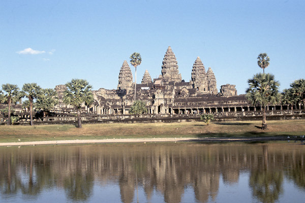
Angkor Wat
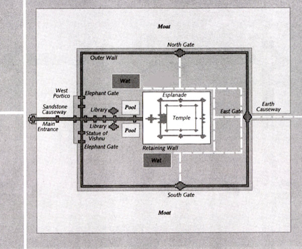
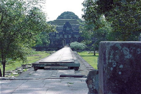
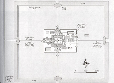
Angkor Wat is an immense monument occupying a rectangular area of about 210 hectares, defined by a laterite enclosure wall which is
surrounded by a moat that is 200 metres wide. The perimeter of the enclosure wall measures 5,5 kilometres. The moat is crossed by a
huge causeway built of sandstone blocks 250 meters long and 12 meters wide.
At 65 metres, the height of Angkor Wat from the ground to the top of the central tower is greater than it might appear, achieved by
using three rectangular or square platforms. Each one is progressively smaller and higher than the one below, starting from the outer
limits of the temple. Covered galleries with columns define the boundaries of the first and second platforms.
At the third level, the platform supports five towers - four of the corners and one in the middle - and these are the most prominent
 |
|||||
architectural features of Angkor Wat. Graduated layers, one rising above the other, give the towers a conical shape and, near the top,
rows of lotuses taper to a point. The overall profile imitates a lotus bud.
Most probably it was constructed as a funerary temple for Suryavarman II (reigned 1112 - 1152) to honour Vishnu,
the Hindu deity with whom the king identified.
The most significant point is that the temple is oriented towards the west. West is symbolically the direction of death, which once
led a large number of scholars to conclude that Angkor Wat must have existed primarily as a tomb. This idea was supported by the fact
that the magnificent bas-reliefs of the temple were designed to be viewed in an anticlockwise direction, a practice which has
antecedents in ancient Hindu funerary rites.
Vishnu, however, is also frequently associated with the west, and it is now commonly accepted that Angkor Wat most likely served as both
a temple and a mausoleum for Suryavarman II.
 |
|||||
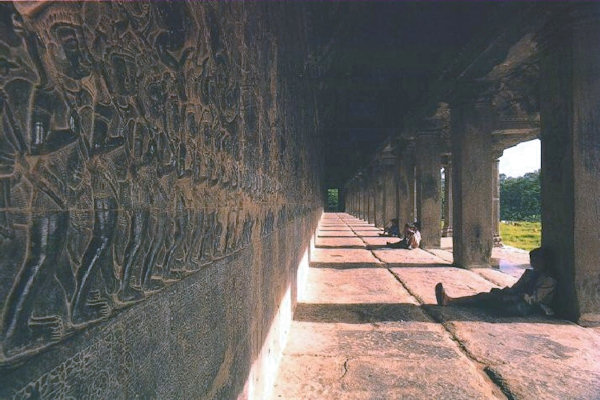
Gallery of Bas-reliefs
The Gallery of Bas-reliefs surrounding the first level of Angkor Wat, contains 1.200 square metres of sandstone carvings. The reliefs
cover most of the inner wall of all four sides of the gallery and extend for two metres from top to bottom.
Each section tells a specific story inspired by one of tree main sorces - either Indian epics, Sacred Books or Warfare of the Angkor
period.
Battle of Kurukshetra is the main subject of the Hindu epic Mahabharata in which the armies of the Kauravas
and the Pandavas march into battle from opposte ends towards the centre of the panal where they meet in combat.
Heaven & Hell
Yama, the supreme judge (with multiple arms, holding a staff and riding a buffalo) points out to his scribes the upper road
representing heaven and the lower one of hell.
 |
|||||
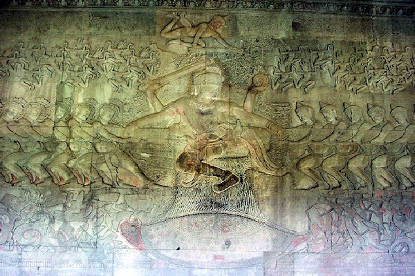
Churning of the Ocean of Milk
This is the most famous panal of bas-reliefs at Angkor Wat and one of the greatest scenes ever sculpted in stone.
The myth derives from the Hindu epic Bagavata-Pourana and centres on gods and demons who have been churning the ocean of milk for
1.000 years in an effort to produce an elixir that will render them immortal and incorruptible.
Battle of Lanka
This is a popular scene from the Ramayana and among the finest of the bas-reliefs at Angkor Wat. It portrays a long and fierce
struggle between Rama and the demon king Ravana.
The Death of Valin
One scene has a fight between the brothers Valin and Sugriva (King of the Monkeys), who are enemies, duel possesion of Surgriva's
kingdom. Rama intervenes and kills Valin by piercing him with an arow.
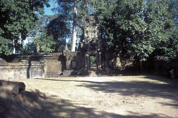
Angkor Thom
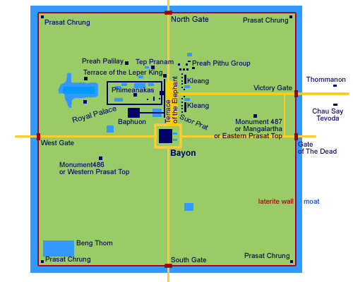
The fortified city of Angkor Thom (Great Angkor"), some 10sq km extent was built by Angkor's greatest king,
Jayavarman VII (reignes 1181-1219). It was grander than any city in Europe at that time and must have supported a considerable
population - which may have been as high as one million. Within the city walls were residences of the king, his family and officials,
military officers and priests while the rest of the people lived outside of the enclosure.
Angkor Thom is enclosed by a jayagiri (square wal) 8m high and 12 km in length and encircled by a jayasindhu (moat) 100m
wide, said to have been inhabited by fierce crocodiles. This is yet another moinumental expression of Mt Meru surrounded by
the oceans, both the city and the symbolic universe recreated by Jayavarman VII after the sacking of Angkor by the Champs.
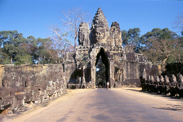
The city has five monumental gates, one each in the northern, western and southern walls and two in the eastern wall. The Gopuras
(gates) which are 20m in height, are crowned by four gargantuan faces of the bodhisattva Avalokiteshvara facing the cardinal
directions. At the base of each gate are finely modeled elephants with three heads. Their trunks are plucking lotus flowers, in theory
out of the moat.
 |
|||||
The Hindu god, Indra sits at the centre of the elephants and holds a thunderbolt in his lower left hand.
The Bayon takes an easy second place after Angkor Wat as the most popular of Angkor's many temples.
It's a place of stooped corridors, preciptous flights of stairs and, best of all, a collection of 54 gothic towers decorated with
216 coldly smiling, gargantuan faces of Avalokiteshvara.
The bayon is now known to have been built by Jajavarman VII (reigned 1181 - 1220), though for many years its origins were obscure.
Shrouded in dense jungle, it also took researchers some time to realise it stands in the exact centre of the city of Angkor Thom.
There is still much mystery associated with the Bayon - its exact function and symbolism - and this seems only appropriate for a monument
whose signature is an enigmatically smiling face.
 |
|||||
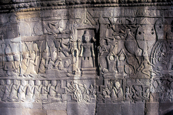
The Bayon Bas-reliefs
The reliefs on the inner gallery are mainly mythical scenes, whereas those on the outer gallery are marked departure from anything
previously seen at Angkor.
They contain genre scenes of "everyday life" - markets, fishing, festivals with cockfights and jugglers and so on - and historical
scenes with battles and processions.
The reliefs are more deeply carved than at Angkor Wat, but representation is less stylised.
The scenes are presented mostly in two or three horizontal panels. The lower one, with an unawareness of the laws of perspective, shows
the foreground, whereas the upper tier presents scenes of the horizon. They both exhibit a wealth of creativity.
 |
|||||
The Baphuon, a pyramidal representation of mythical Mt Meru.
Construction probably began under Suryavarman I (reigned 1002 - 1049) and was later completed by Udayadityavarman II
(reigned 1049 - 1065).
The Terrace of the Elephants extend over 300 metres in length from the Baphuon to the Terrace of the Leper King.
The south stairway is framed with three-headed elephants gathering lotus flowers with their trunks. The central stairway is decorated by
lions and garudas in bas-reliefs in a stance of support for the stairway.
Terrace of the Leper King owes its name to a statue of unknown date of the god Yama which previously sat on top of the terrace.
As the statue was covered with lichen, local inhabitants thought it represented a king who had contracted leprosy after having been
splashed by the blood of one of his counselors whom he had just killed.
 |
|||||
Royal Palace
The vast site of the Royal Palace, immediately to the north of the Baphuon, was surrounded by a five-meter-high laterite wall from the end
of the 10th century.
Accesses through five gopura of modest size, the palace compound, whose wooden buildings have disappeared, was screened by a wall and
was the location for the small Phimeanakas temple, thought to be a kind of royal chapel.
According to the Chinese traveller Zhou Dagaun, who spent several months at Angkor at the end of the 13th century, this was where
the ruler went each evening to couple with a serpent spirit in the form of a woman, so magically assuring the prosperity and peace of
the kingdom.
To the nort of Phimmeanakas, there are two ponds; Royal Baths, that where part of the Royal Palace.
 |
|||||
Tep Pranam, an 82m by 34m cruciform Buddhist terrace was once the base of a pagoda of lightweight construction. Nearby is a
Buddha 4,5m high.
Along the east side of the Central Square are two groups of buildings, the North Kleang and the South Kleang, that may
at one time have been palaces.
Prasat Suor Prat is a row of 12 square laterite and sandstone towers, six on either side of the road leading to the Victory Gate,
parallel to the front of the terraces.
According to a Cambodian legend, the towers served as anchoring places for ropes which streched from one to another for acrobats
performing at festivals, while the king observed there performances from one of the terraces. This activity is reflected in the name of
the towers; Prasat Suor Prat means "The Towers of the Cord Dancers".
Preah Khan
Preah Khan, an extensive 56 hectares Buddhist complex was built in AD 1191 as a monastry and centre for learning by the
Khmer King Jayavarman II (1181-1219) and dedicated to his father Dharanindravarman II.
Four concentric enclosure walls subdivide Preah Khan. The outer or fourth wall, which is encircled by a wide moat, today encloses a
large tract of jungle, formerly the living quarters of the monks, students and attendants of Preah Khan.
The secondenclosure wall delinaetes the principal religious compound of about four hectares within which there is a dense concentration
of temples and shrines.
The central complex is Buddhist. The northern and western sectors are dedicated to Hindu sects of Vishnu (west) and
Shiva (north), whilst the southern sector is a place of ancestor worship. The eastern sector forms the grand entance to the
central shrine.
A 2 metre high stone stela inscribed on all four sides, now under the security of the Conservation Office gives a wealth of
information about the temple and its functions.
The inscriptions indicate that the complex was built on a battle site where Jayavarman VII finaly defeated the Chams. In those days it was
known as "Nagarajayacri" which translated from Siamese means "The City of the Sacred Sword"
 |
|||||
Four processional walkways approach the gates of the temple and these are bordered by another stunning depiction of the
Churning of the Ocean of Milk".
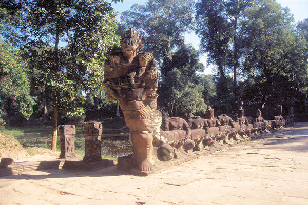
The Garudas - the mythical Hindu bird and mount of Vishnu - along with the Nagas they hold, are symbolic protectors of
the air and water and sixty eight of them placed approximately 35 meters apart around the outer enclosure wall serve as the mythical
guardians of Preah Khan.
Many of the interior walls were once coated with plaster held in place by holes in the stone. Today many delicate carvings remain,
including essai (wise men) and apsaras.
In the central shrine the king consecrated, in addition to 515 other statues, an image of the bodhisattva Avalokiteshvara (one of
the most important divinities of Mahayana Buddhism) In the 15th or 16th century the statue of Lokeshvara was replaced by a stupa.
There is also a curious Mediterranean-style two-storey structure inside the east gate, the purpose of which is unknown.