Ladakh
Things to DO
Delhi
 |
|||||
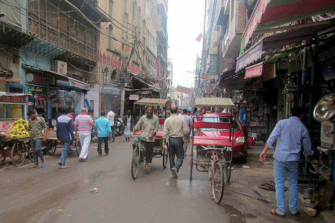
The Chandni Chowk is one of the oldest and busiest markets in Old Delhi. It was built in the 17th century by Mughal Emperor
of India Shah Jahan and designed by his daughter Jahanara.
The original Chandni Chowk, half-moon-shaped square, itself was located in front of Municipal Townhall and its reflection use
to shine in the moonlit water pool located in front of it. The pool in the chowk was replaced by a clock tower ("Ghantaghar") until
the 1950s.
Khari Baoli is known for Asia's largest wholesale spice market selling a variety of spices, nuts, herbs and food products like
rice and tea. Operating since the 17th century, the market is situated at the western end of the Chandni Chowk.
Fatehpuri Masjid was built in 1650 by Fatehpuri Begum, one of emperor Shah Jahan's wives. Flanked by minarets, the mosque
has a traditional design with the prayer hall having seven-arched openings. The mosque has single and double-storeyed apartments
on the sides.
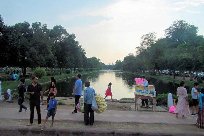
The main east-west axis of New Delhi is the ceremonial boulevard Rajpath. The avenue is lined on both sides by huge
lawns, canals and rows of trees. At the western end of Raipath on Raisini Hill
 |
|||||
stands the official residence of the president
of India. Completed in 1929, the palace-like building has an elegant Moghul garden and occupies 130 hectares.
India Gate; The 42-metre-high stone arch of triumph stands at the eastern end of Rajpath. It bears the name of 90.000
Indian Army soldiers who died in the campaigns of WW I, the North-West Frontier operations of the same time and the 1919 Afgan fiasco.
Agrasen ki Baoli is a 60-meter long and 15-meter wide historical step well. Although there are no known historical
records to prove, it was originally built by the legendary King Agrasen and the present architecture hints at it being rebuilt
in the 14th century during the Tughlag period of Delhi Sultanate.
The planning for the Metro in Delhi had started in the 1950s. Physical work on the project started in October 1998. With the first
section of the fully elevated Red Line opened in 2002, the Delhi Metro has become one of the largest and busiest metro system worldwide
with a total length of 348 km along with 253 stations.
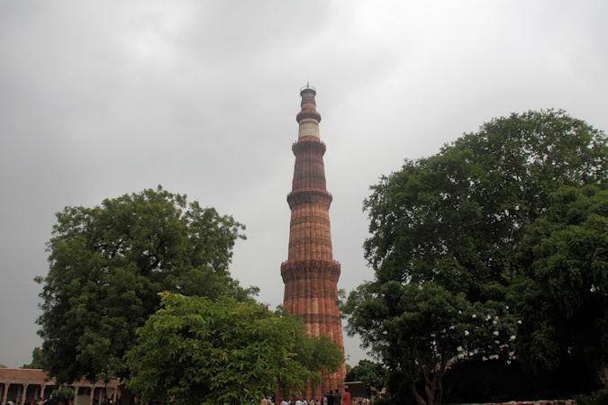
The buildings at the Qutab Minar Complex, 15 km south of New Delhi, date from the onset of Muslim rule in India and are
fine examples of early-Afghan architecture.
The Qutab Minar itself is a soaring tower of victory which was started in 1193, immediately after the defeat of the last
Hindu kingdom in Delhi. It is a 73 metres high and tapers form a 15-meter-diameter base to just 2 1/2 metres at the top. The first
three storeys are made of red sandstone, the fourth and fifth of marble and sandstone.
Athough Qutb-ud-din Aibak began construction of the tower, he only got to the first storey. It was continued by his successor
 |
|||||
Shams ud-Din Iltutmish, and finally completed much later by Firoz Shah Tughlaq, a Sultan of Delhi from the
Tughlaq dynasty in 1368 AD.
At the foot of the Qutab Minar stands the Quwwat-ul-Islam Mosque, the first mosque to be built in India. Qutb-ud-din Aibak
began constructions of the mosque in 1193, but it has had a number of additions and extensions over the centuries.
The Alai Darwaza is a main gateway from southern side of the Mosque. It was built by the second Khalji Sultan of Delhi,
Ala-ud-din Khalji in 1311 AD, who also added a court to the eastern side.
In the courtyard of the mosque stands the Iron Pillar, ( 7,21-metre high). It was originally erected by Chandragupta II
in front of a Vishnu Temple complex at Udayagiri around 402 AD, and later shifted by Anangpal in the 10th century from
Udaygiri to its present location. Anangpal built a Vishnu Temple here and wanted this pillar to be a part of that temple.
The tomb of Shams ud-Din Iltutmish, who died in 1235 is by the north-west corner of the mosque.
Amritsar
 |
|||||
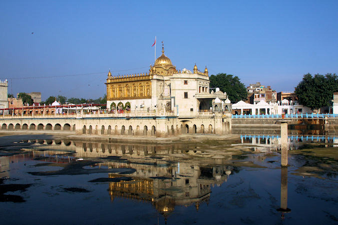
Founded in 1577 by Ram Das, the fourth guru of the Sikhs, Amritsar is both the centre of the Sikh religion and
the major city of Punjab state - where the majority of Sikhs live. Amritsar or "pool of nectar" is the name of the sacred
pool by which the Siks' golden temple is built.
The Temple was repeatedly rebuilt by the Sikhs after it became a target of persecution and was destroyed several times by the
Mughal and invading Afghan armies.
Maharaja Ranjit Singh, after founding the Sikh Empire, rebuilt it in marble and copper in 1809, and overlaid the sanctum with
Gold foil in 1830. This has led to the name the Golden Temple.
The Golden Temple is an open house of worship for all people, from all walks of life and faiths. It has a square plan with four
entrances, and a circumambulation path around the pool.
The temple complex has a Langar, a community-run free kitchen and dining hall. Food is served here to all visitors who want
it, regardless of faith, gender or economic background.
 |
|||||
The Durgiana Mandir derives its name from the Goddess Durga, the chief Goddess who is worshipped here. Statues of
Lakshmi and Vishnu are also located and worshipped in the temple.
The temple is built in the middle of a sacred lake. A bridge provides the approach to the temple. The dome of the temple is gilded.
Marble is used extensively in the temple's features. The temple is sometimes called Silver temple because of its large exquisitely
designed silver doors.
The lowering of the flags ceremony at the Attari-Wagah border is a daily military practice that the security forces of
India and Pakistan have jointly followed since 1959.
The ceremony starts with a blustering parade by the soldiers from both sides, and ends up in the perfectly coordinated lowering
of the two nations' flags. The spectacle of the ceremony attracts many visitors from both sides of the border, as well as
international tourists.
Dharamshala
 |
|||||
"Dharamshala" literally means "a spiritual dwelling" and in loose translation as a shelter or rest house for pilgrims
and travellers. When the first permanent settlement was created in the place now called Dharamshala, there was one such pilgrims'
rest house on the site, and the settlement took its name from that dharamshala.
The Tibetan settlement of Dharamshala began in 1959, when the Dalai Lama had to flee Tibet and Jawaharlal Nehru, the
then Prime Minister of India allowed him and his followers to settle in McLeodganj, a former colonial British summer picnic spot
10 kilometers to the north of Dharamshala. There they established the "government-in-exile" in 1960 and the Namgyal
Monastery.
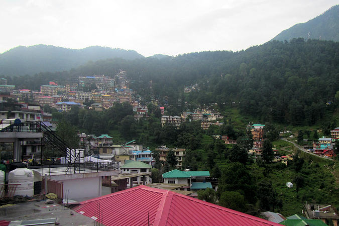
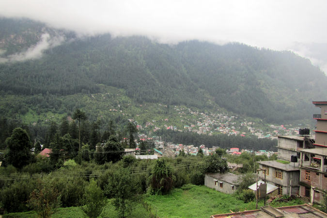
Several thousand Tibetan exiles have now settled in the area; most live in and around McLeodGanj in Upper Dharamshala, where they
have built monasteries, temples and schools. It has become an important tourist destination with many hotels and restaurants,
leading to growth in tourism and commerce.
 |
|||||
In the early 1980's, Kalsang Yeshi, Minister of the Department of Religion and Culture, and his wife Kim Yeshi
began to imagine an institute in India which could act as a cradle for the preservation of Tibetan art, and provide a haven for
artists to practice their crafts. The goal was to return Tibetan art to its former glory, following the strictest standards in terms
of the selection of materials, quality of craftsmanship, and adherence to traditional methods.
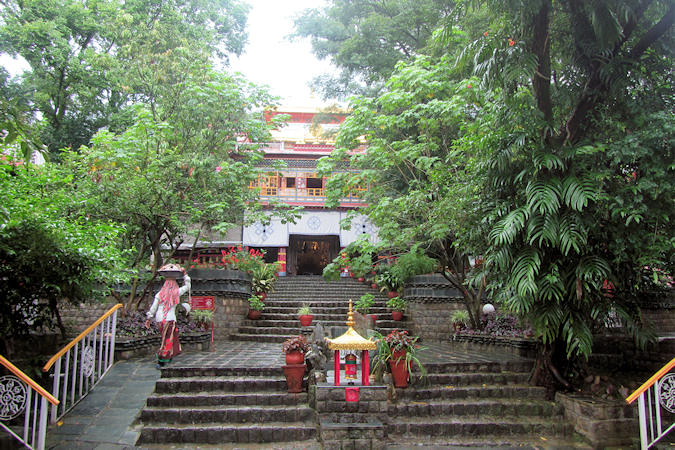
In 1995, Norbulingka Institute was officially inaugurated by His Holiness the Dalai Lama.
The institute is known for its 1.173 murals of Buddha, frescoes of all the Dalai Lamas and drawings chronicling the life of the
14th Dalai Lama.
In the main hall stands the 4 mt high gilded copper Buddha Sakyamuni statue, one of largest such statues outside Tibet.
The Losel Doll Museum has diorama displays of traditional Tibetan scenes, using miniature Tibetan dolls in traditional costumes.
Manali
Manali is named after the hindu lawgiver Manu. The name Manali is regarded as the derivative of "Manu-Alaya"
which means "the abode of Manu". Legend has it that Manu stepped off his ark in Manali to recreate human life after
a great flood had deluged the world.
The small town, with a population of about 8.000, is the beginning of
 |
|||||
an ancient trade route to Ladakh
The Hidimba Devi Temple was built in 1553 AD by Maharaja Bahadur Singh. The temple is built around a cave where
Devi Hidimba performed meditation.
The Indian epic Mahabharata narrates that the Pāndavas stayed in Himachal during their exile. In Manali, the strongest
person there, named Hidimb and brother of Hidimba, attacked them, and in fight Bhima, strongest amongst the Pandavas,
killed him.
Bhima and Hidimb's sister, Hidimba, then got married and had a son, Ghatotkacha, (who later proved to be a great warrior in
the war against Kauravas). When Bhima and his brothers returned from exile, Hidimbi did not accompany him, but stayed back and
did "tapasyā" (a combination of meditation, prayer, and penance) so as to eventually attain the status of a goddess.
Manali-Leh Highway
Manali-Leh Highway is a 490 kilometers long highway; connecting the town of Manali in Himachal Pradesh to that of Leh in
Ladakh; 230 kilometers is in Himachal Pradesh and the remaining 260 kilometers in Ladakh. Sarchu acts as the border between two states.
 |
|||||
The road is open for roughly around four and a half months in a year, from June till mid October when snowfall again blocks the
high altitude passes en route. The average elevation of Manali-Leh highway is more than 4.000 meters; its highest elevation is
5.328 m at Tanglang La mountain pass.
Sukhdev Singh Gill — assistant executive engineer of Central Engineering Services (Class 1) — can rightly be called as
Father of Manali Leh highway. Gill was posted at the high altitude areas between Manali and Leh in August-September 1955 and
conducted surveys for a road connecting the two cities.
Because of the important position of Ladakh between China and Pakistan this Highway plays an important strategic role for India,
which results in the maintenance of the road by the Indian Army itself.
In addition to the spectacular landscape the life on and next to the road is diversified because of a wide variety of people
frequenting it. Construction workers from other parts of India are working for better road conditions during the summer.
 |
|||||
Manali - Keylong (118 km)
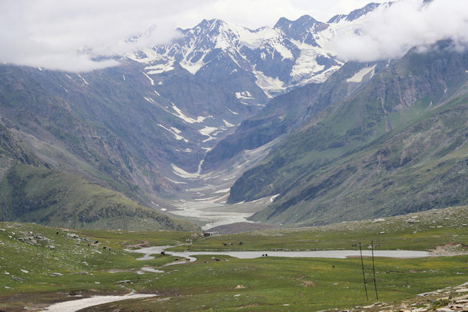
Situated about 53 km from Manali, Rohtang Pass (3.979 m) connects Kullu valley with Lahul and Spiti valley. The name
Rohtang means "ground of corpses" or "pile of dead bodies" due to the number of people who lost their lives trying
to cross it. The pass sits on the watershed between the water basins of the Chenab River and the Beas River, and offers beautiful
sights of glaciers, peaks, Lahaul Valley and the Chandra River.
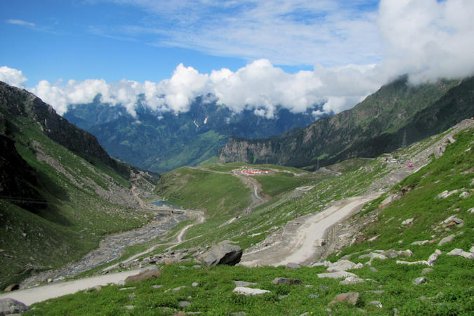
The road is in dreadful condition; Winding bends, steep drops down with no barrier, rock falls and landslides all create a recipe
for disaster. Traffic jams are common as military vehicles, trucks, and goods carriers try to navigate the tight roads and rough
terrain, compounded by snow and ice at certain points and the large number of tourists vehicles.
After the pass, it takes about 25 km to find the Sissu Waterfalls; fed by the surrounding glaciers.
 |
|||||
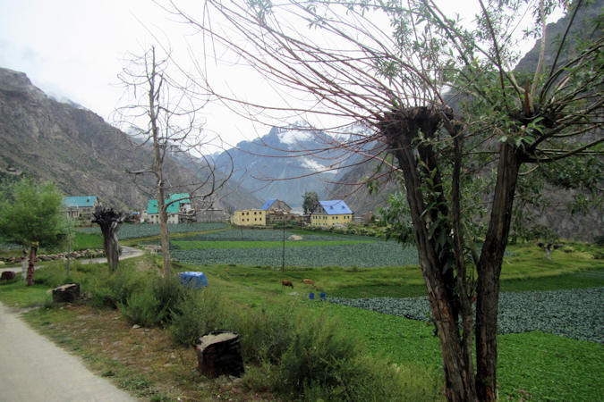
Keylong is the district headquarters of Lahaul and Spiti district and is home to most of the government offices and
facilities in Lahaul. At the top of the nearby Gumrang village is a small temple
dating to the second half of the 12th century.
Keylong - Sarchu (112 km)
Kolong is a small village located 12 km north of Keylong. Agriculture is the main source of livelihood.
After crossing Kolong, the greenery completely disappears and the mountain slopes on the leeward side become brown and arid.
Bara-lacha la is the next high mountain pass (4.850 m) situated about 39 km from Kolong.
Sarchu is a military base and has a police check post. Sited on the banks of the Tsarap river it is a major halt point
with tented accommodation on the Leh-Manali Highway.
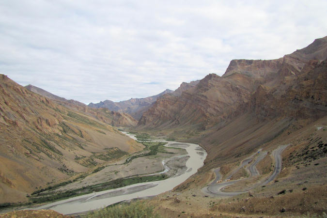
Sarchu - Leh (260 km)
Gata Loops (15 km north of Sarchu) is a series of 22 hairpin bends, starting at 4.190 m near the Tsarap river and ending after 12,5 km at the top of Nakeela La at 4.739 m. Continuing the road for about
 |
|||||
7 km there is the Lachulung La; a pass at an elevation of 5.059 m above the sea level.
The next stretch of 40 km crosses a plateau at 4,700 m called Kiang Chu Thang. Kiang Chu Thang means a plain where the kiang
(Tibetan wild ass) does not find water. At some places, it runs along the Sumkhel Lungpa River, featuring stunning sand and
rock natural formations.
Located at an altitude of 5.328 m above sea level Taglang La is the second highest mountain pass in Ladakh.
Before reaching the Indus river at Upsi there is the smaal village of Gya. A Buddhist Gompa with accompanying
chortens or stupas is situated above the village and the gorge.
After Upsi it takes a 48 km drive along the Indus river to reach Leh.