Sudan
Things to DO
Old Dongola
The remains of the medieval city of Old Dongola sit on a hill overlooking the east bank of the
Nile. From the 7th to the 14th centuries the city prospered as the capital of the Christian Kingdom
Makuria, controling the river from the First Cataract south along the Dongola Reach, possibly even as
far as Atbara. As an urban centre, Old Dongola's location was well chosen. The land was agriculturaly rich,
the walled city easily defensible and trade along the Nile (as well as the desert caravans from Darfur)
easily controlled.
Throughout its history there was a seemingly unending period of church building.
 |
|||||
The Church of Granite Columns: was 30 m in length by 25 m in width and composed of fired red bricks.
Its most striking feature, after which it was named by archaeologists, were the sixteen monolithic columns
supporting its roof. It was built in the late 7th century on the site of an earlier church. The building
was strongly influenced by Greek and Byzantine architectural styles.
The Cruciform Church is 45 m long by 40 m in width. Although its walls have only partially survived,
they have a maximum height of four metres, giving an impression of the fast size of the church in its
prime.
As its name suggests, the church is shaped like a gigantic cross. This style of church building did not
previously exist in Nubia and provides more evidence for the shift in Nubian Christianity from the Egyptian
Coptic Church to that of Byzantine Orthodoxy. It was constructed sometime in the 9th century, and was
extensively rebuilt during the 500 years it was in use before its final rebuilding and abandonment in
the 14th century.
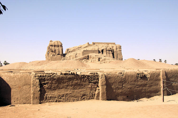
The most prominent surviving building is the so-called Throne Hall, a massive two-storey edifice
with metre-thick walls. The Throne Hall was built between the 9th and 10th century. Its exact function
is unknown, but it most likely served as a royal purpose.
 |
|||||
Downstairs features a series of narrow, barrel-vaulted chambers, without any windows and possibly used as
a storage area.
There is a separate door for the stairs to the upper-level, which is completely distinct from the ground
floor. Here, several columns remain surrounding a square throne hall or audience room. On the walls there
are traces of a painted floral band and the figures of Christ and a Nubian bishop.
In 1323, the Muslim Kanz ed-Dawla was placed on the throne of Old Dongola, marking the end of
Christian rule. The throne hall was converted into a mosque. Its frescoes were whitewashed over and a
plaque mounted in the wall of the upstairs hall to proclaim the glory of Allah - it is still
in situ
The mosque was in regular use as recently as 1969.
The nearby cemetry is also worth a visit. The Domed Mausoleum, called Qubba contains the grave of a
Saint or some important personage.
Traveling along the Nile
 |
|||||
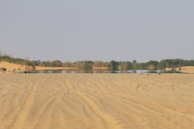
North of Dongola, the vieuws are always changing.
The cool blue and brown waters of the Nile appear and disapear amid swats of palm tree and carefully tended fields. Villages
pass by with their men in gleaming white jallabiyas riding donkeys and women in bright bilowing tobes.
Away from the river there are rocky scarps, golden sand dunes and great piles of basalt boulders that lie strewn in the desert.
It's spectacular country
For the most part, the road north closely follows the Nile, and you are never more than a few kilometers from the nearest village
- good news for those with their own vehicle in the event of mechanical problems.
The father you travel from Dongola, the more expensive many goods become. Smal markets and a transport infrastructure that is
still being developed have an inflatorian effect on items such as bottled water(they almost dubble the price you'd pay in Khartoum)
 |
|||||
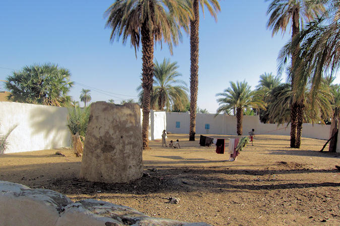
On our way up north we made visits to some Nubian Village's
Ayad (our guide) spent a while explaining how Nubians live and work, and it was all very interesting.
The homes are built of mud bricks, were neat and large since several generations share a home, and
colorfully painted.
The Nubians appreciate the extra money they get from allowing tourists to visit their homes, and they also
sell handicrafts.
No hassle either!
They know that tourism give an extra income for the local economy, and they want to do their part to help
encourage more visitors.
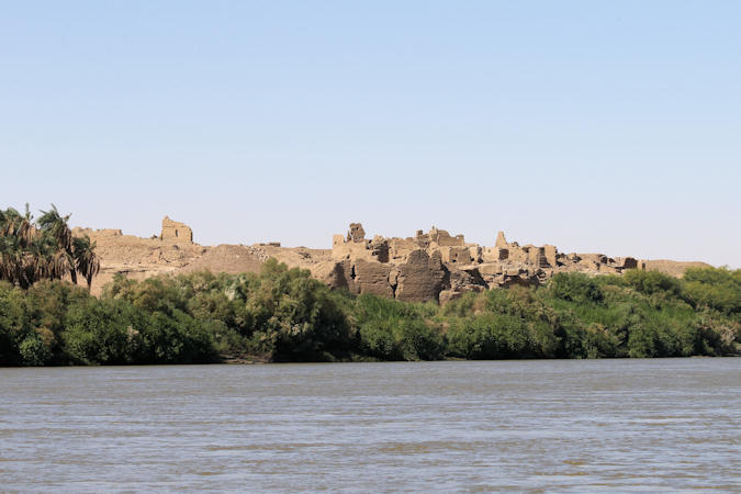
Kerma
Kerma owes its name to the modern city located south of the Third Cataract, on the east bank of the Nile, where
are found the most important remains of this civilisation: the Kingdom’s Capital and its Eastern Necropolis.
The heart of the city was a structure now known as the Western Defuffa, a local term for a mud-brick structure. It was
probably the most important religious building in Kerma.
 |
|||||
In shape it resembles an Egyptian temple, consisting of a tower-like structure with a rectangular block behind it. Inside the
Defuffa there was only a narrow corridor and a stairway leading to a flat roof.
In the Classic Kerma period (c. 1750-1600 BC), the Deffufa and its workshops and other buildings were surrounded by an enclosure
wall, thus forming a religious quarter.
The Kerma necropolis is one of the most impressive in Nubia, notably because of its innumerable circles of black and white
stones that mark the location of the burials.
The surface of the necropolis is close to 90 hectares and the number of burials is between 30.000 and 40.000; the size of
the largest burials is 90 metres in diameter.
The burials are earthen tumuli strengthened by several concentric circles of black and white stones Their size vary according to
periods and the rank of the deceased.
 |
|||||
The Egyptian conquest of the Kingdom of Kush is carried out by one of the most illustrious New Kingdom pharaohs,
Thutmosis I (1496-1483 B.C.). After having recaptured the forts of Lower Nubia and seized Kerma, he establishes a new
city one kilometre north of the latter, at the site of Dukki Gel.
During the clearing of a temple in January 2003, the excavation of a pit containing 40 black granite statue fragments confirms
the site’s importance.
There are seven monumental statues; they represent the two last kings of the Twenty-fifth Dynasty, Taharqa and
Tanwetamani, and three of their successors: Senkamanisken, Anlamani and Aspelta, identified by
inscriptions on the back pillar.
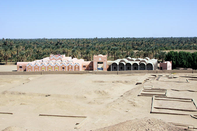
A museum founded in 1999, has become a major cultural venue for the inhabitants of Kerma, who value the enhancement of Nubian history
and the role the museum plays in the development of the region.
 |
|||||
The building is inspired by traditional Nubian architecture with a vaulted roof; the many vaults are pierced by triangular openings
that allow daylight into the museum galleries.
While certain rooms are administrative offices and workspace for the curators, the majority is dedicated exhibition space.
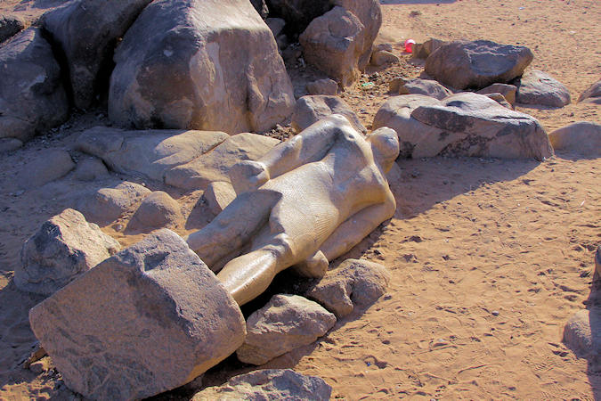
Tombos
An important granite quarry was located here in the Pharaonic era.
Its stone was used mostly to build statues and buildings between the river delta and the southern regions of the kingdom.
A statue to the Pharaoh Taharqa, abandoned for over 2700 years, is still lying there.
Around the quarry some inscriptions can be found left by Tutmose I to commemorate his conquest of Kerma
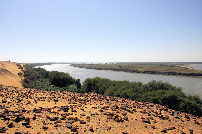
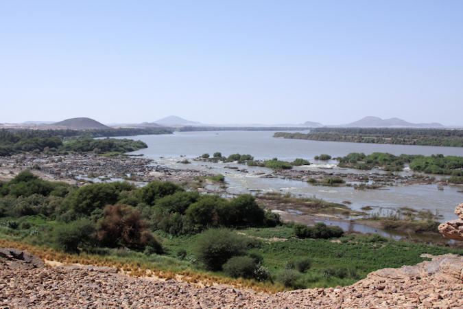
3rd Cataract of the Nile
 |
|||||
The Cataracts of the Nile are shallow lengths (or white water rapids) of the Nile River, between Aswan and Khartoum, where the
surface of the water is broken by many small boulders and stones jutting out of the river bed, as well as many rocky islets.
In some places, these stretches are punctuated by whitewater and are perhaps well characterized as rapids, while at others the
water flow is smoother, but still shallow.
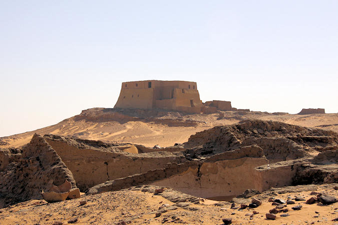
A Turkish Fortress near the Third Cataract offers superb views over the Nile.
Rock Art
For more than 10.000 years, the population of the Nile Valley and the Sahara have decorated the rock face with animal
and human figures, either carved directly into the rock or painted with pigments.
At different eras a variety of subjects were depicted; wild animals, cattle and herdsman, Egyptian-style boats, horses and
also cammals.
Near Sabu we visit one of the richest sites of rock engraving in the Sudan, with hundreds of images from prehistoric to Egyptian
times.
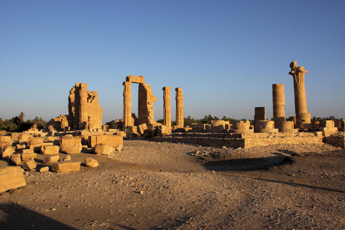
Located immediately south of the Third Cataract on the west bank of the Nile river the Temple of Soleb is probably the
best-preserved Egyptian temple standing on the Sudanes Nile.
Soleb was built by Amenhotep III in the 14th century BC and was dedicated to Amun and Nebmatre
(the lord of Nubia, a representation of the pharaoh himself).
Leading from a terraced temple on the Nile banks, a processional way led up to approach the First Pylon, standing within an enclosure
 |
|||||
wall fortified with bastions. Two pairs of obelisks stood in front of and behind the First Pylon, after which an
avenue of ram-headed sphinxes led to the Second Pylon, before which stood two obelisks and six colossi.
These latter were subsequently removed to allow construction of a large kiosk structure with four palm columns each about 14 metres
high.
The two courts beyond featured collonades of well-proportioned papyrus columns.
The main sanctuary structure possessed three east-west axes, incorporating hypostyle halls and triple sanctuaries.
Soleb temple has relief carvings showing the Sed festival of Amenhotep. The sed was a celebration of renewal, first enacted in
the 30th year of a pharaoh's rule, and than every three years therafter. It was the most important ritual in a pharaoh's reign,
regenerating his rule and assuring his reugn in the afterlife.
The exact procedure of the ceremony is unknown, but representations of the Solar Eye (the ruling god Amun) and the
Lunar Eye (a lioness godess Tefnut-Mehit)are shown integral.
The fact that the sed festival may have been celebrated here on the Egyptian-Nubian frontier is intriguing, as the luan eye is
also associated with Horus, the falcon-headed god and protector of the pharaoh. Horus lost his eye in battle with his brother
Seth, a fight that was said to have taken place in Nubia.
 |
|||||
Located between the second and third cataracts of the Nile Sai Island has been inhabited since the Palaeolithic.
Two kolometres south of the ferry landing are the remains of a mud-brick Ottoman fort, built in the 16th century when the
region formed the boundery between Egypt and the rising power of the Funj Kingdom of Sennar far to the south. As an
illustration of the role Nubia has played as a frontier; the fort is constructed on the stone remains of a New Kingdom
Egyptian town built nearly 3.000 years aerlier.
The site is currently being excavated by French archaeologists and is difficult for the non-specialists to interpret.
There are four villages on Sai Island. If you walk inland from the ferry towards them you pass four upright granite columns of a
Medieval Church. Crosses can clearly be seen carved on the capitals wich are all that remain to mark this outpost of the
Nobatian Kingdom.