Iran
Things to DO
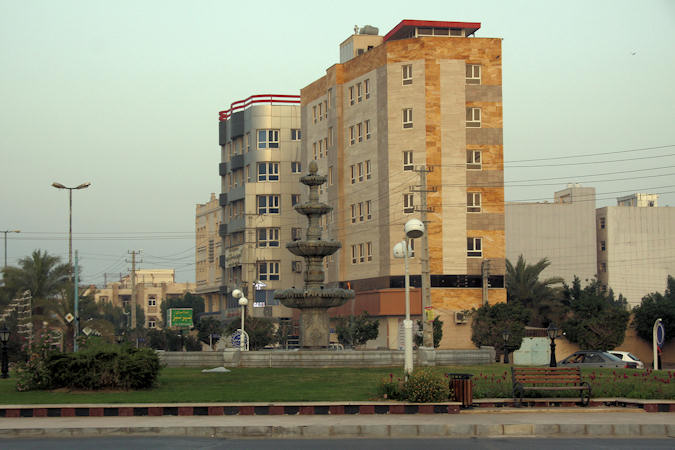
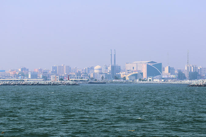
Bushehr
 |
|||||
The strategic location of city of Bushehr has been the main reason for the establishment of the port of Bushehr.
During the 1st and 2nd Millennium BC, the Peninsula of Bushehr was a thriving and flourishing seat of civilization called
"Rey Shahr".
In 1734 Nader Shah of Afsharid dynasty chose it as the site for an Iranian naval base. During the Zand era, the region was
a place for political challenges between different political groups.
When the Qajar dynasty replaced the Zand dynasty, they gain less control on the region of the Persian Gulf, so the British influence
in the region increased gradually.
At the end of the 18th century, the British and Dutch transferred their regional commercial offices to Bushehr, and during the 19th century
the town was prominent as the home of the British political agent for the Persian Gulf.
This situation lasted til 1913 when Britain moved its diplomatic and commercial center across the Persian Gulf to the Arabian Peninsula
 |
|||||
Siraf was an ancient Sassanid port used as an important shipping route between the Arabian peninsula and the Far East;
the port was destroyed in 970 AD.
The Siraf Jame Mosque was built on top of a large Sasanid fort constructed shortly after 804 AD.; only ruins survive today and
most of its architectural elements coms from excavations in 1973.
The complex of numerous crypts dug into the ground is the mysterious secret of Siraf. Some archaeologists believe that these holes were
graves dating back to ancient times while some other believe that these hand dug holes were used as water wells. The impenetrable stone
walls of the holes kept the rain water all year long.
Further research is required to determine the exact usage of this complex.
Qeshm Island
 |
|||||
The earliest evidence of human presence at Qeshm dates back to the Paleolithic Period. According to historical records, Qeshm
Island has been famous as a trade and navigation center.
Its economy flourished in the 8th and 9th century AD, during the Dailamites and Buyid eras, as trade vessels sailed
between Qeshm Island and China, India, and Africa.
Qeshm is a duty-free zone, but in a gulf increasingly full of gleaming skyscrapers it remains refreshingly attached to the
age-old Bandari way of life.
If you're after an authentic island experience, Qeshm won't disappoint. Here, locals wear traditional dress, live in houses cooled by
"badgirs" (wind towers) and work in boat-building yards turning out lenges, the large wooden cargo boats that have criss-crossed the gulf
for centuries.
There is a ferry at Bandar-e Pol, which takes about 15 minutes to reach the island.
 |
|||||
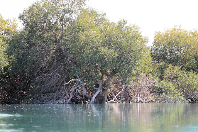
Dominated by the species Avicennia marina, known locally as "harra tree", the Hara forests represent an important
ecological resource where commercial use is restricted to fishing (mainly shrimp), tourist boat trips, and limited mangrove cutting
for animal feed.
The most obvious architectural features of the houses in Bandar-e Laft is their variously-sized windbreaks (windtowers). The
people of Laft constructed them for making the inner space of the building cool in summer.
Centuries ago people of this area dug 366 wells in the stones to gather clean water from rainfall. They are called Tallaght
Wells.
According to scientists the number 366 represent the number of days in a leap year. Today only about 60 of them are left and half of
this number is usable for extracting water.
 |
|||||
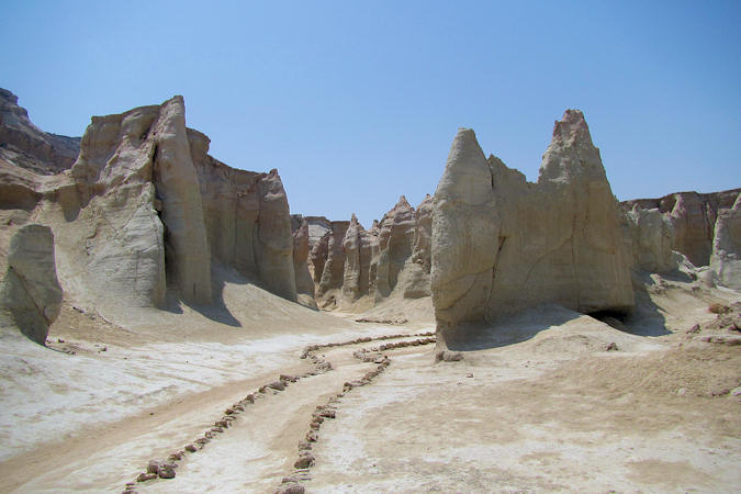
The Star Valley is a unique example among all Geosites to study erosion. The local name for this area is “Estalah-kaftah”
which means “the Fallen Star”.
The reason for naming this area as such is that the locals believe that once upon a time a star (commit) (meteor) has hit the earth at
this site and as a result of this collision, the stones and soil have been thrown in the air and been frozen, forming these geological
structures.
There are also local beliefs regarding the presence of Ghosts and “Jinns” in this Valley during the dark which may be due to
the unusual geological forms and wind blowing into the Valley at night.
The geological morphology of this site is the result of erosion by rainstorms, wind and gravity on various layers.
In areas where the geological structures are more resistant to erosion, they have remained intact, however in areas with softer
geological structures, erosion has altogether degraded and vanished those parts.
 |
|||||
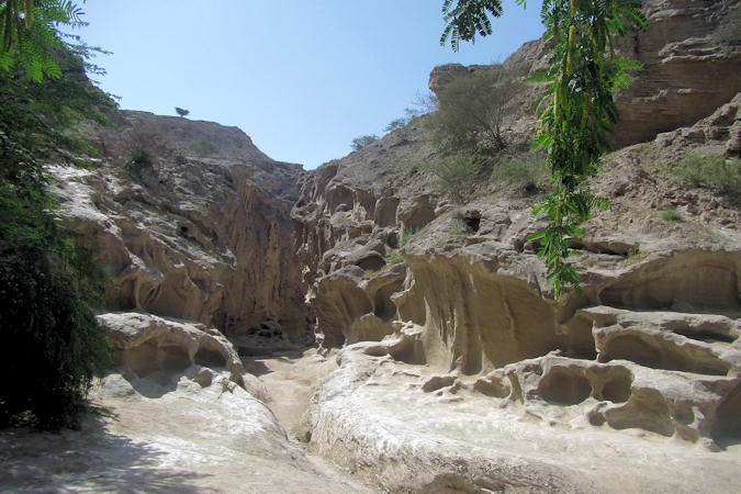
Chahkuh Gorge is an exceptional example of erosion through rainstorm water. Heavy rainstorms (that are also rare) quickly
flush water through geological structures.
Erosion however has been a secondary factor in forming this beautiful valley. In fact, it has primarily been affected by the Salt Dome
and related anticline. An anticline is a fold that is convex up and formed due to tectonic compression.
While under pressure, these arch-like structures may break in areas that are weaker, forming grooves on the walls.
The presence of concave and round structures or linear and oval structures on the walls of the valley is the result of erosion by water.
One of the main characteristics of geological formation of this geosite is its impermeability to water, which keeps the water in holes
and grooves, causing further erosion.
The locals have taken advantage of this structure by digging wells inside the main axis of the valley to act as water reservoirs.
 |
|||||
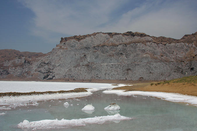
Namakdan Salt Complex hosts the longest salt cave of the world (Namakdan Cave) that is 6km in length.
Salt domes are formed when a huge amount of salt moves towards the earth’s surface due to its light structure compared to its surrounding
structures.
The Salt domes have many interesting aspects such as salt falls, salt springs and salt caves, with various geological formations that have
been prone to erosion and dissolution processes.
Rainwater gradually penetrates the Salt Dome through its crevices, allowing the water dissolve the salt and enter the dome.
Some of the most amazing structures that may be found inside the Salt Cave are Stalactites and Stalagmites, as well as saltcrystals
(such as needle-shaped, round, or multi-facet) formed by sedimentation of salt.
In addition, in some areas where waterhas penetrated to the ground, some beautiful ponds have been formed with salt crystals at the bottom.
 |
|||||
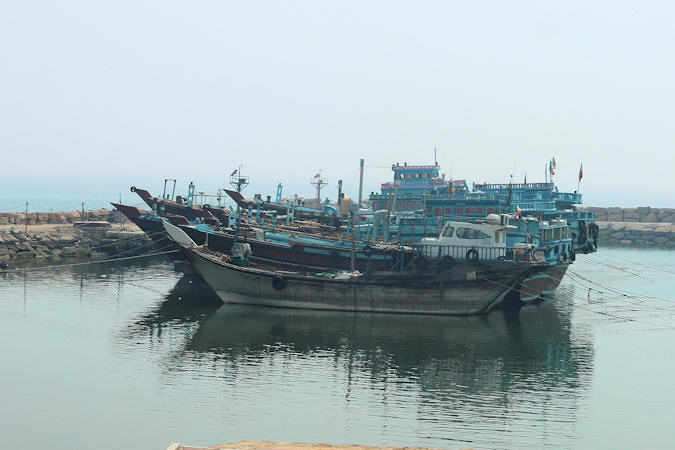
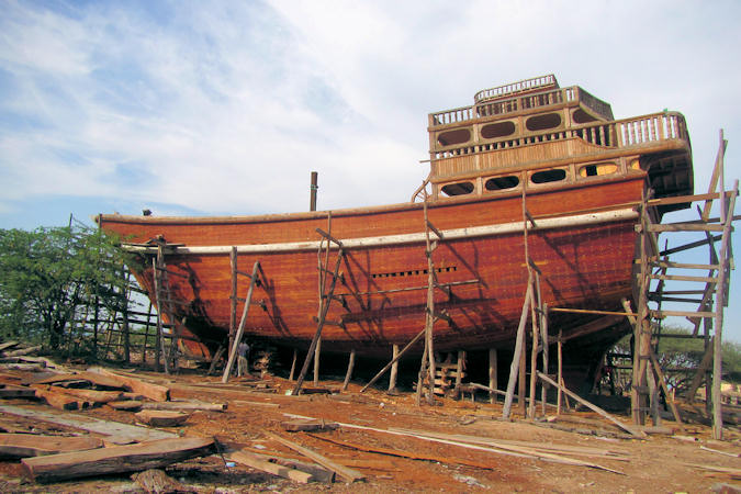
At Guran an ancient ship building tradition survives that is reminiscent of biblical times in its simplicity and
workmanship.
The Lenj is a traditional wooden boat, made with planks, that has been used in the Persian Gulf for fishing, travel, trade
and pearl diving for centuries.
A full size lenj could easily cover longer distances - between India and Africa - and would sometimes stay at sea for up to a year.
There is not much to see in the Qeshm town but if you get the ferry to Bander-e Abbas here you might want to go for a
wander before getting onboard.
There are some markets and also plenty of shops and malls as Qeshm is a duty-free zone and many locals come from mainland Iran to buy
cheap electronics!
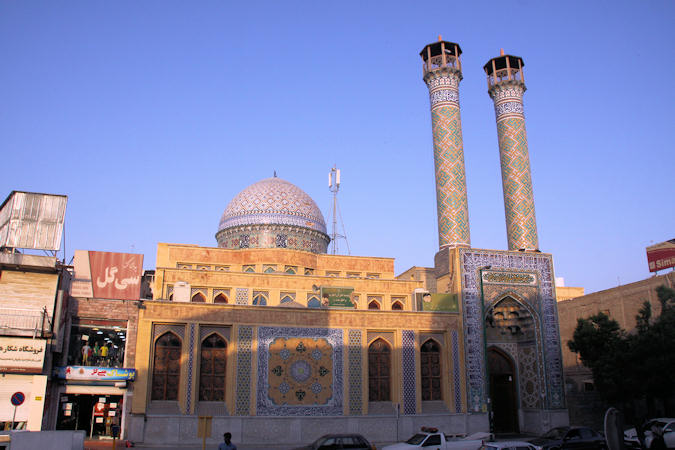
Bandar-e Abbas
 |
|||||
Bandar-e Abbas was the name given to the medieval port of Gameron in 1615 by the Safvid Shah Abbas I after
ejecting the Portugese from their forts here and on Hormuz Island in 1622, ending both their occupation and their strategic and commercial
control of the Strait of Hormuzthat had lasted since 1515.
Work on the port facilities in 1964-67 and then the setting up of the Iranian naval headquaters in 1973 meant increased business and an
international deep-water port was constructe in 1976-86.
Now Bandar-e Abbas is the main port of Iran.
Iran have threatened to close of the Strait of Hormuz on multiple occasions, most notably in 2008, 2012, 2018 and 2019.
Traditionally, the motivations of the threats have been a response to U.S. provocations, and a number of economic sanctions posed on
Iran by the U.S, targeting both the Iranian oil market, as well as other economic sectors.
 |
|||||
The Nasseri Mosque was built in 1886 by Mohammad Ali Nasseri. The architecture style of the mosque is according to
local style of the southern areas of Iran and its ceiling also is made of Sandal Wood which had been imported from India.
The thriving, bustling bazaars are fun, offering a very different range of goods imported mainly from the Far East.
Parts of the bazaar are renovated, making place for luxurios Shopping Malls.
Genoo Thermal Spring is situated at a distance of 34 km northeast of Bandar Abbas.
The water from this spring which is calcium sulfuric in nature is used for irrigating the palm groves or plantations and also for
bathing purposes. This spring is equipped with two segregated pools for ladies and gents.