Iran
Things to DO
Hormuz Island
 |
|||||
In 1505 the reign King Manuel I of Portugal led Portugal to establish a policy of expansion in Africa and western Asia.
During attempts to expand Portuguese influence into the Indian Ocean, the Portuguese duke Afonso de Albuquerque captured the
island in 1507 and it was incorporated into the greater Portuguese Empire.
The island became an emergency stopover point for Portuguese ships travelling to Goa, Gujarat and nearby Kishm.
The Ottomans laid siege to the island under the famous admiral and cartographer Piri Reis in 1552.
In 1622 the island was captured from the Portuguese by a combined Anglo-Persian force at the behest of the English East India
Company.
After a period of Omani administration in the 19th century, it remained a sparsely inhabited fishermen's island before experiencing
some development in the later years of the 20th century.
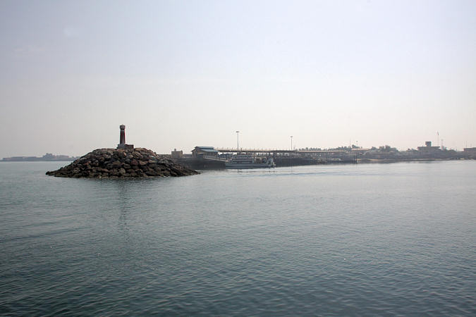
Travelers can go to Hormuz island on ferries from Bandar-e Abbas, departing from the Shahid Haqani Passenger Port. It takes
about 30 minutes.
 |
|||||
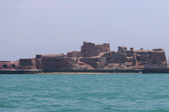
The building of the castle was ordered by Portuguese commander Afonso de Albuquerque in 1507 and finished in 1515
naming the fort: Fort of Our Lady of the Conception.
The Persian Safavid king, Abbas I of Persia (1587–1629), wanted to end Portuguese rule in the south and eventually managed to convince
the British East India Company to allow its ships to cooperate with his land forces to seize the island from the Portuguese in 1622.
Originally the fortress was completely surrounded by water, but now the sea laps around less than half of the walls.
By the main entrance are the Prison dungeons but you need a torch to explore. A walk across the main courtyard leads to the
Underground church, whose cross-groined vaults are supported on great columns; the altar must have stood where the entry now
is.
From here it is a short walk to the splendid Underground cistern, built with an inner walkway around it.
 |
|||||
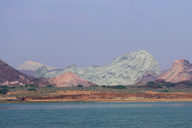
Hormuz Island has an area of 42 km2. It is covered by sedimentary rock and layers of volcanic material on its surface.
The highest point of the island is about 186 metres above sea level.
Due to a lack of precipitation, the soil and water are salty. Hormuz is also the geologists’ paradise where they can discover a wide
range of minerals.
The best way to explore the whole island is to hire one of the local guides waiting on their pickup motercycles at the boat terminal. They
can also arrange a boat-trip around the island.
You're driver will willingly accompany you through the multi-couloured rocky landscape and show you around.
Salt and associated sedimentary and igneous rocks with seawater running through have over de centuries created a remarkable landscape,
locally known as "Kuh-e Namak" (salt mountain).
 |
|||||
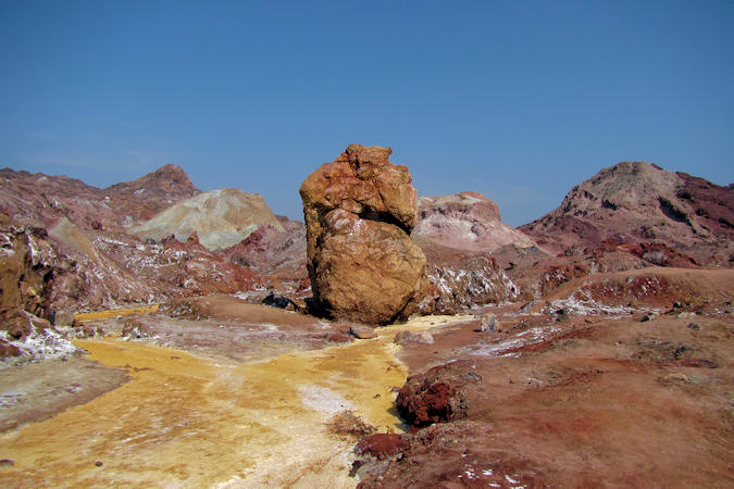
Located at the southwest of the Island, Rainbow Valley is a narrow valley with multi-colored soil surrounded by colorful
mountains. It is painted with more than 70 colors and a variety of stones and minerals which make this place an interesting destination
for geologists.
The yellow, red, silver and black colors are mainly of clay and iron oxide compounds, while the white, blue, pink and grey are made of
volcanic compounds.
Hormuz is best known for its ochre, a red-coloured earth pigment that has made miles of this land look majestic.
Traditionally, the ochre was used in everything from decorative arts to wedding ceremonies and even as a spice for fish and
torshi (pickled vegetables). Now the ochre is transported by the truckload and exported.
The Gazella Plains is the area where the Indian gazelle lives on the hormuz and one of the attractions is the possibility
of viewing the gazelles from a distance.
Minab
 |
|||||
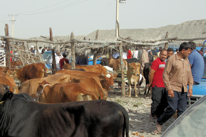
Minab is famous for fishing (especially shrimps) and for agriculture (especially date palms and mangoes).
Once a week, a well known bazaar called Panjshambe bazar attracts people from all over Hormozgan, and beyond.
The peoplen come from across Hormozgan Province to the market to both buy and sell anything and everything, from embroidered trousers
and fabrics to essentials such as vegetables and fruit. There is also a cattle-market for selling cows/sheep and goats.
Most locals wear different attire from other provinces of Iran, with women often sporting colourful dresses instead of the typical
black chador, and men in Arab-style clothing.
But the boregheh (masks) worn by many Bandari women, both Sunni and Shia, are probably the most striking of all.
The styles vary according to region, ethnicity, but most noticeably according to religious affiliation. Shia women wear red rectangular
masks, while those of Sunni women are black or indigo with gold
Bam
 |
|||||
The city of Bam is located in a vast plain between the two mountain ranges of Barez and Kabudi. The region around the city
has long been known for its date palms, which are among the most productive in Iran, although cotton and various grains are also
raised there.
On 26 December 2003 an earthquake measuring 6.6 on the Richter scale struck the Kerman province. The earthquake was particularly
destructive in Bam, with the death toll amounting to at least 26.271 people and injuring up to 30.000.
The ziggurat of Jiroft, about 100 km south of Bam, known also as the Konar Sandal was discovered in 2002. This structure dates to
around 2200 B.C. Some believe that the ziggurat was built by the Aratta, who is mentioned as a legendary Bronze Age kingdom in
Sumerian texts.
More excavations and reserach has to be done to reveal the secrets.
 |
|||||
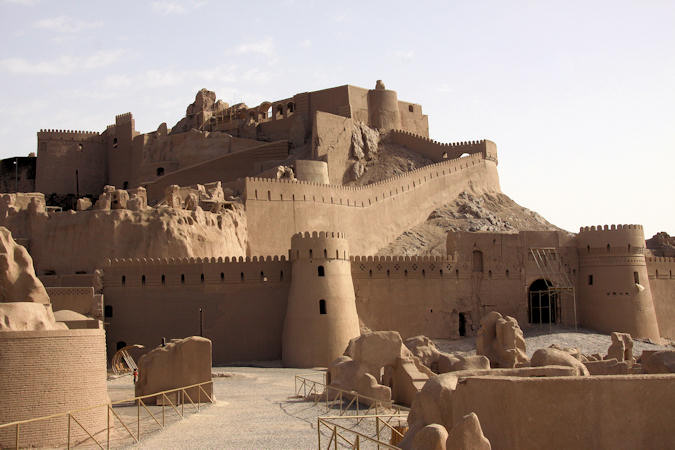
There is no precise archaeological dating of the buildings of the Citadel of Bam. But through historic sources and ancient texts,
the first human settlement in the area can be traced back to the fort built by the Achaemenians around 579–323 BC.
During the Parthian rule (247 BC–224 AD), the fort was expanded and became Arg-e-Bam, the Citadel of Bam. New fortifications and
walls were constructed between 224 and 637 AD.
The heyday of the citadel was from the seventh to eleventh centuries, when it was when it was one of the key stops on the Silk Route
transporting goods between Asia, Europe, and the Middle East.
On December 26, 2003, the Citadel was almost completely destroyed by an earthquake, along with much of the rest of Bam and its
environs. A few days after the earthquake, the Iranian President Mohammad Khatami announced that the Citadel would be rebuilt.
Mahan
 |
|||||
Mahan is believed to have been named after the Persian general Adarmahan, who led the troops of Anushirawan the Just
on the western frontier of the Sassanid Empire against the forces of the Eastern Roman Empire (Byzantine) during the
Byzantine–Sassanid War of 572–591.
Mahan is known as the city of gardens and caravanserais
Bagh-e Shazdeh ("Prince Garden") is 5.5 hectares with a rectangular shape and a wall around it. It consists of an entrance
structure and gate at the lower end and a two-floor residential structure at the upper end.
The distance between these two is ornamented with water fountains that are engined by the natural incline of the land.
The garden was built originally for Mohammad Hasan Khan Qajar Sardari Iravani ca.1850 and was extended ca.1870 by
Abdolhamid Mirza Naserodollehand during the eleven years of his governorship in the Qajar dynasty.
 |
|||||
Shah Nematollah-e Vali spent many years wandering through central Asia perfecting his spiritual gifts before finally settling
at Mahan, where he passed the last twenty five years of his life.
He died in 1431, having founded a Darvish order which continues to be an active spiritual force today.
The central domed burial vault, completed in 1437 was erected by Ahmad Shah Bahmani, king of the Deccan, and one of Shah Nematallah’s
most devoted disciples.
Shah Abbas I undertook extensions and renovations in 1601, including reconstruction of the tiled blue dome.
During the Qajar period the site was particularly popular, necessitating the construction of additional courtyards to accommodate
increased numbers of pilgrims. The minarets also date from this period.